I’ve had quite a few emails recently from Orca, a navigation equipment and software firm, boasting about the 3 metre location accuracy of their equipment as a major selling point. It’s a waste of marketing effort, as far as I’m concerned.
Three metre satellite accuracy – available nowadays even on some top of the range phones – is no use when round much of the British Isles chart positions can be far less accurate.
Orca equipment and software do look temptingly attractive on paper, and I have no doubt that their 3 metre claim about their GNSS equipment is accurate. But that’s not how we should be thinking about satellite positions in practical navigation.
In many places we sail, such as the Western Isles, the West of Ireland and, much nearer to home, most of the Thames Estuary, it’s particularly risky to expect your charts to be able to match anything like that standard.
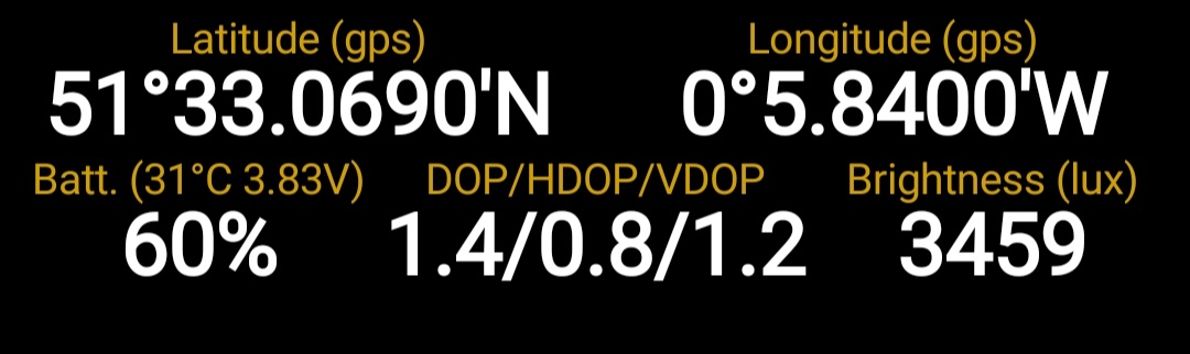
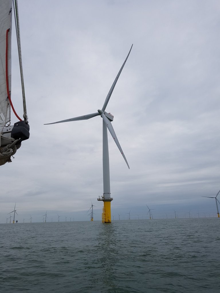
In the Thames Estuary, 3 metre satellite accuracy is irrelevant for a small boat that needs to keep out of the main channels and use swatchways and other routes less frequented by commercial traffic. The only short cut I know where the chartplotter positions are reliable is through the London Array windfarm, which you’d expect to be charted and updated to high precision.
But generally, the depths are changing all the time and charts cannot keep up outside the main ship channels. Valiant efforts are made by amateurs to track the changes, especially East Coast Pilot and Roger Gaspar’s Crossing the Thames Estuary
They publish plenty of examples of rapidly changing profiles of the sea bed. Recently they noted how several yachts had gone aground together on the Sunk (I think it was) because they followed their chartplotters.
Last year (2021) we crossed the Sunk in May and by August when we came back to the Solent an alert had already been put out by Gaspar that the sand had shifted the swatchway since the spring. No published chart of the Thames Estuary, paper or electronic, can keep up with that pace of change.
Ireland has been updating the once notoriously old surveys of its West Coast, and charts were supposed to have been much improved by the last time we visited. But inshore, for instance along the Connemara coast, we still assumed 100 metres error, to give ourselves a safe margin. In some places, that meant focusing on old methods, and ignoring the plotter.
In the west of Scotland, Bill Bradshaw has done a great service over the last 15 years or so with his Antares charts of anchorages. We have used them, and hope to again, but they are not official charts. In fact, one thing they have done is expose how out of date other paper and electronic inshore charts actually are, based on surveys sometimes unchecked since the 19th century.
I’m not criticising the Orca products, which I’m sure are fine, and I will try out their app next season. It’s the marketing message that I take issue with.
Update, Jan 2023: Bill Bradshaw gave an excellent talk in London this month on his charts, and on the deficiencies of official charts in Scotland. It was organised by the Little Ship Club and the Royal Institute of Navigation (of which I’m a member).
