My post from four years ago about the pronunciation of the word bowsprit still seems to be getting quite a bit of attention, judging by the number of times it’s consulted. I wrote that I don’t think rhyming the first syllable with ‘cow’ is authentic, though that’s how most people pronounce it nowadays.
Somehow or other, pronunciation of this word touches on a nerve, drawing out the pedant in all of us. So here’s more grist to the mill:
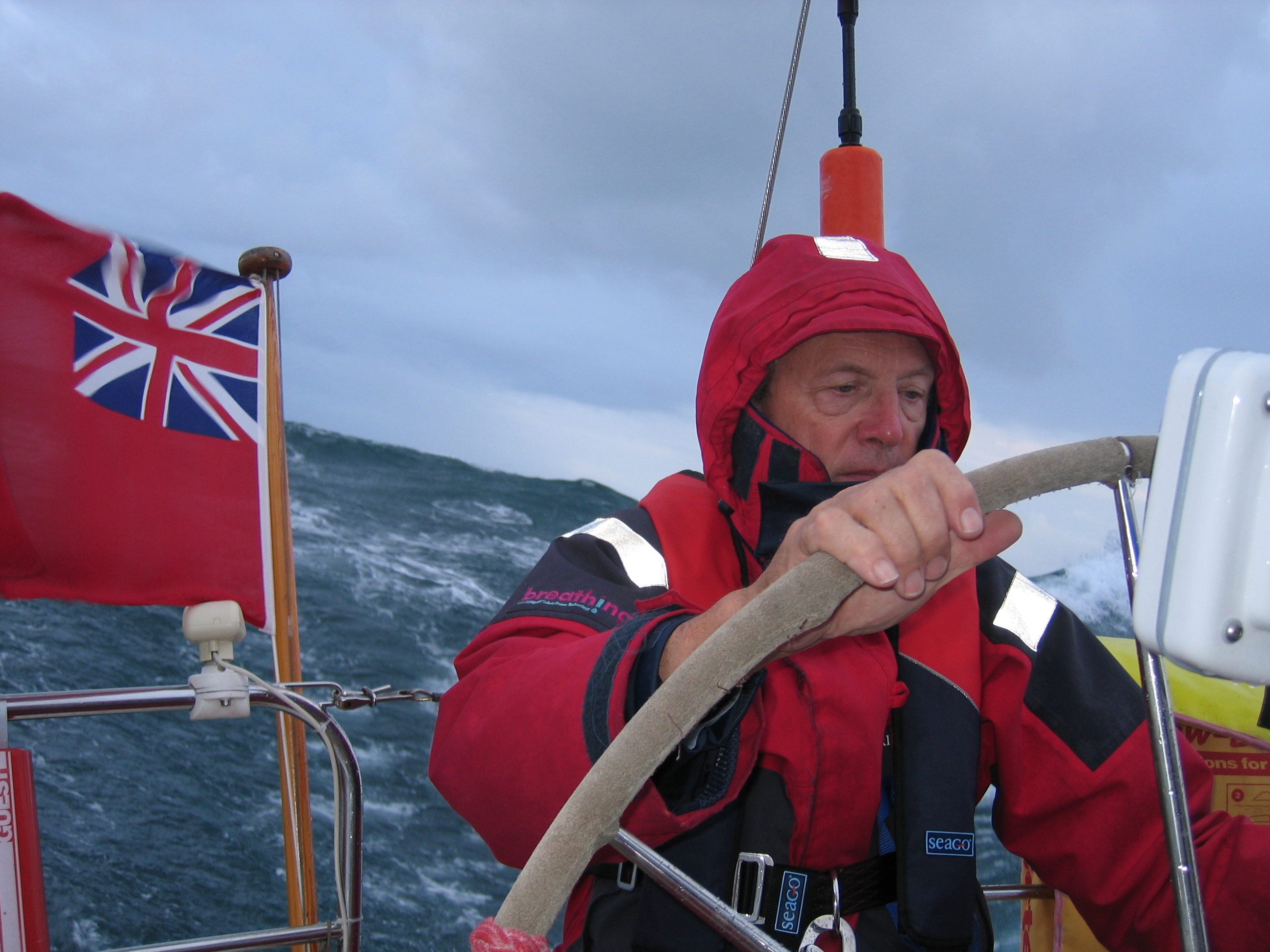
Tiredness is dangerous at sea, and it creeps up faster as we grow older, so we need to think hard about how best to avoid it. Having good equipment is obviously vital, but top of my list of priorities is not hardware but changing our attitude to the challenges of weather and sea. We must take the lazy option, and stay where we are if it looks too much like hard work out there.
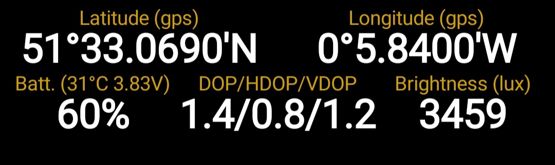
I’ve had quite a few emails recently from Orca, a navigation equipment and software firm, boasting about the 3 metre location accuracy of their equipment as a major selling point. It’s a waste of marketing effort, as far as I’m concerned.
Three metre satellite accuracy – available nowadays even on some top of the range phones – is no use when round much of the British Isles chart positions can be far less accurate.
Every river I know with saltings has timber rubbish stranded near the high tide line, usually broken and ignored. A close look, however, tells a better story. Today’s flotsam is often a fragment of a very old boat, and the best of all is a piece of long-lasting teak.
Insurance surveys don’t come round very often, but it’s a finger chewing time when they do. What’s going to be found and how much will it cost?
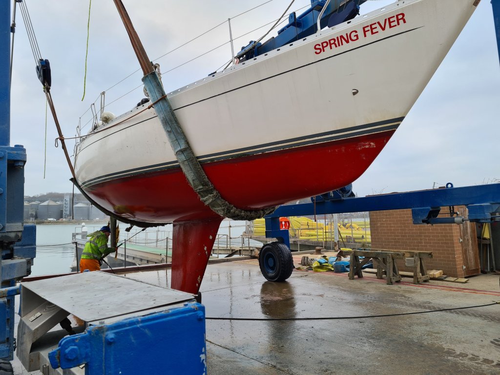
We’ve been lucky with our insurers, who haven’t insisted on a survey since we bought Spring Fever in 2009. Our current insurers gave us a year’s notice that we’d need one this winter.
The survey has just been completed by Adrian Stone of Cowes. The good news is that the main work needed is a job we have been contemplating anyway, which is replacing the standing rigging.
Out of the water and pressure scrubbed.
It still looks acceptable on close inspection, but one of the risks with stainless wire and fittings is sudden failure, as likely from a hidden crack in a steel piece as from the wire itself. Some insurers are said to ask for replacement every 10 years but our standing rigging has lasted a full 13 seasons.
It seems that while my phone is accurate to an error of considerably less than 10 metres, the industry is heading to even better precision of a tenth of that level, and soon. This post looks at why that means satellite accuracy on all devices including smartphones is reaching levels where there are diminishing returns for small boat sailors.
In general, 5 metre satellite accuracy has been available on smartphones for a considerable time now. I give links at the end to industry, US government, academic and consumer articles that give more detail on how accuracy has been developing (and see also my earlier post ‘and a phone to steer her by’).
One of the secrets of the top performers such as the high-end Samsung phones, which can achieve 2 metres, is that they now have dual frequency satellite aerials so they can make the best use of the latest improvements not only in the US GPS, but the Russian Glonass, European Galileo and Chinese Beidou satellite systems. Nowadays, phones will often have as many as 40 satellites in the sky from which to choose the best signals.
Mobiles have had a bad press as navigational tools, but if I were forced to choose one single piece of electronics to take to sea it would be my phone. That’s not a popular view among professionals.
Instructors, coastguards and rescue services learn of many cases where boat owners, especially of powerful motor yachts and RIBs, set off for the open sea with nothing beyond a chart app on a mobile phone, and no knowledge of the underlying skills needed to navigate safely. For the Royal Yachting Association, mobiles are well down the list of recommended priorities, because of the risk that they will be used badly. Textbooks give stern warnings that you must not use them for navigation.
In one corner, the Royal Yachting Association, declaring pyrotechnic flares are obsolete. In the other, the UK Maritime and Coastguard Agency, pointedly renewing for another 2 years its ruling that flares are mandatory under the Safety of Life at Sea (SOLAS) convention, though softening it a little round the edges.
What does it actually mean for a typical small yacht? The crucial issue here is that SOLAS distress signals are only a legal obligation for yachts above 13.7 m or on smaller craft licensed for commercial use, including sail training. They must carry flares. This means if you charter a yacht, it has to have them. The RYA has, however, won a dispensation allowing private yachts from 13.7 to 24 metres to at least dispense with parachute rockets, easily the least useful and most hazardous in use of the flares. Continue reading “Battles over flares”
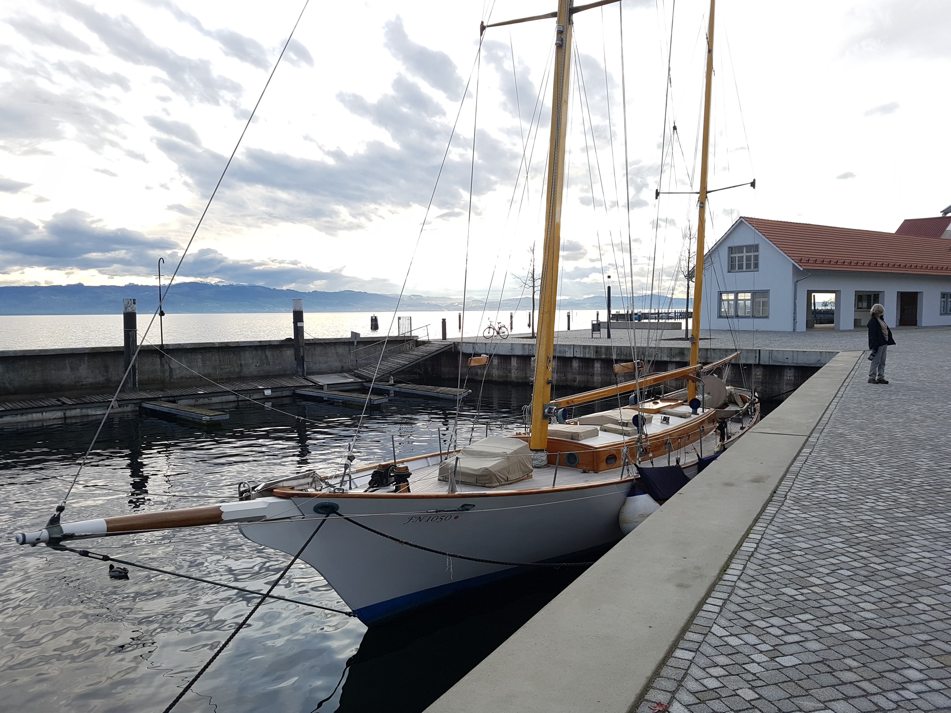
How do you pronounce bowsprit? I’m usually against language pedants, who try to foist the views of Victorian grammarians onto the 21st century. But this word is my one little obsession, ever since getting a letter into Yachting Monthly on whether the first syllable of bowsprit should rhyme with dough or cow.
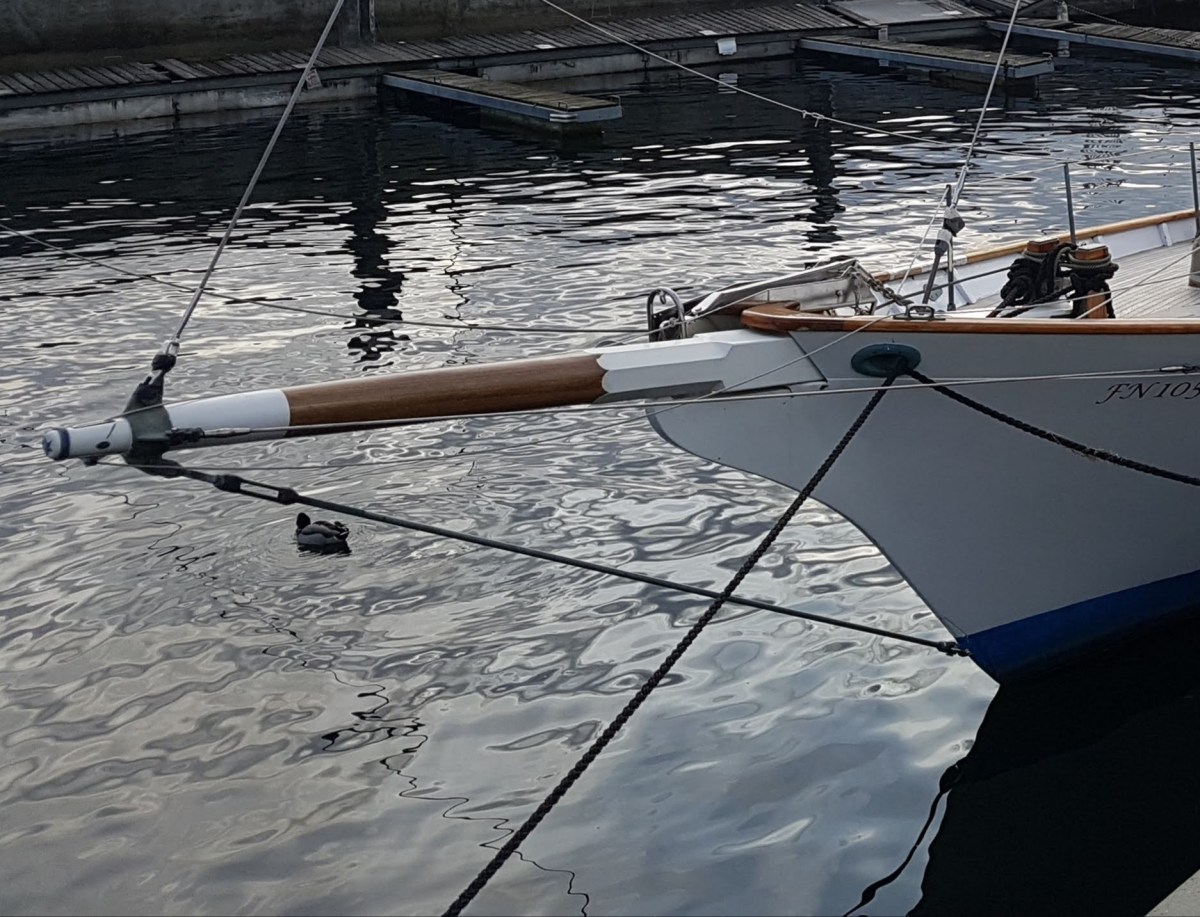
I was reminded by contemplation of this lovely boat recently.
I can’t remember why or when, but I learnt to pronounce bowsprit to rhyme with dough as a child. In fact, the similar word bowline is always pronounced like dough.
So why the difference?Nobody contradicted me on bowsprit till adulthood, partly, I suppose, because I did not know anyone with a boat with one.
But once I met people who used the word practically rather than just read about it, I found myself in a tiny minority: indeed, a handful of people I met were so irritated by my pronunciation that I wrote to Yachting Monthly for a ruling.They published the letter and the deputy editor sent me a private note saying he agreed with me that it should rhyme with dough – but it was obviously too sensitive an issue for such an important journal to take sides in public!
The Oxford English Dictionary agrees it should rhyme with dough, deriving the bow in bowsprit from Middle Low German and Middle Dutch. The online OED can speak the word, too, and it is my way.
I know I am being a touch inconsistent, because I am also convinced that language should evolve the way people actually use it, and not be held back by pedants (see books by David Crystal and David Shariatmadari).
So mine may be a losing battle. The reality is that the pronunciation of bowsprit has changed with popular usage – but don’t expect me to give in any time soon….
See this update in February 2024
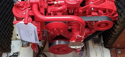
A new engine is a big challenge, not just financially but in the thought process running up to the decision.
Our Volvo is 30 years old and we had it taken out and largely rebuilt 10 years ago. It has been reliable since then but this winter it has been increasingly difficult to start, and the expert verdict was that the valves probably needed regrinding. Continue reading “New engine calculations”
Marina internet is a waste of time. It’s fun doing a live blog of a cruise, but it was so difficult to get web access on our 900 mile round trip to the Morbihan this summer that I failed to file anything en route, and will do a single post later.
How we got marina wi-fi in Vannes, but nowhere near the boat. (The jacket shelters the tablet from the rain).
Every single marina over 4 weeks advertised wi-fi, and only one actually delivered it in practice at a decent speed, with the rest either intermittent and unworkably slow, available only a few yards from the marina office, or simply not showing up on my tablet’s wi-fi source list. Some marinas openly confessed to technical problems, others were incredulous at our inability to log on. At most marinas, it was a cheek to advertise wi-fi at all. Maybe sailing magazines should be taking this on as a campaign.
There were cafes and restaurants, of course, but we went to drink and eat not write in a corner. I’ve also filed posts in the past from my phone using 3G, but we seem to have consistently chosen places where the 3G signal was poor, so that didn’t solve the problem either.
We arrived at Ardoran Marine on 4 May to stay at one of the three chalets the boatyard owns, with a few days fitting out planned. (Peter, Christine, Tony, Elaine and Nigel). Ardoran stores boats in an old quarry behind the main workshop, and we found Spring Fever in excellent condition, dry inside and well cared for, with the anti-fouling done ( a present to ourselves because of the 500 mile drive to reach her.) Continue reading “Fitting out at Ardoran, 4 -11 May”


 I can’t remember why or when, but I learnt to pronounce bowsprit to rhyme with dough as a child. In fact, the similar word bowline is always pronounced like dough.