Back to the future – electronics on board

I was intrigued by the equipment list below, which is more than three decades old, because it was a reminder of how long we have been arguing about the risks and rewards of electronic navigation. I found the list in some old files I was checking last year for the sixth edition of Pass Your Yachtmaster by David Fairhall and Mike Peyton, which I was commissioned to update by Adlard Coles*.

A 1989 list of yacht electronics talked about at the Boat Show

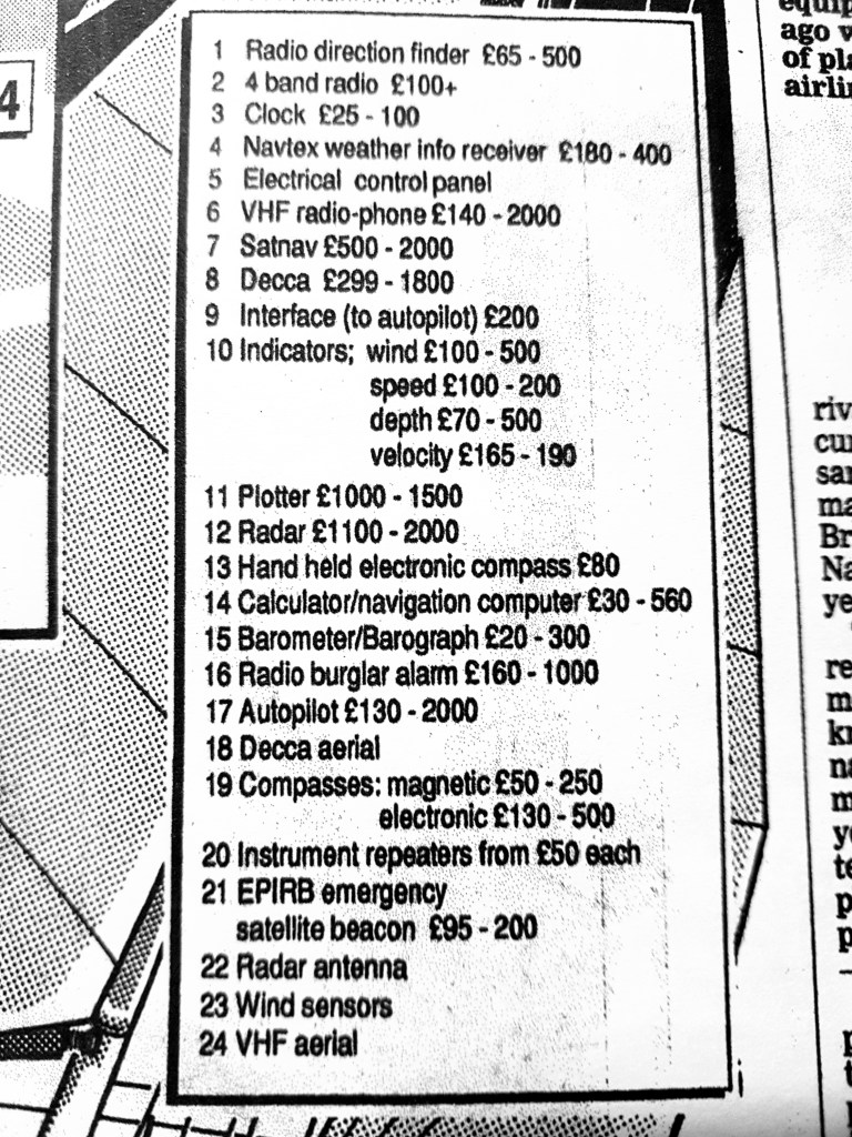
The list was part of an article I produced for the Guardian newspaper about electronics for small boat navigation, under the headline ‘And a satellite to steer her by’, researched by talking to manufacturers due to appear at that year’s London Boat Show. I had forgotten all about it.

Continue reading “Back to the future – electronics on board”

Satellite accuracy on a mobile

How accurate is the position calculated by your smartphone? The Royal Institute of Navigation is sceptical. Its new book on electronic navigation for leisure sailors says: “At sea, mobile phone positioning uncertainty will typically be several hundred meters or more, which may be enough to put us into danger”.

I am looking for some proper studies on this issue, because I am sceptical about that statement. In the meantime it’s easy to check what your phone tells you about its own location performance when it relies only on satellite signals.

Continue reading “Satellite accuracy on a mobile”

Relearning old navigation lessons

Two letters in the latest issue of the excellent Cruising Association magazine* claim it is now safe to rely entirely on electronic charts because backups to the boat’s main chartplotter are so cheaply available. You can leave your old paper charts abandoned in the bottom of a locker somewhere, the argument goes.

However, while researching updates for the yachtmaster book I mentioned last month, I’ve been re-reading intensively about old fashioned navigation techniques I learnt a long time ago, some of which were beginning to fade from memory. It has reinforced for me how important it is to avoid total reliance on electronics and have a portfolio of navigation skills including the old ones. Continue reading “Relearning old navigation lessons”

February – averting satellite disaster

The British government turns out to have been ahead of the game on the  satellite risks I mentioned last month, with a £36 million programme just announced to  prevent navigational satellite failures damaging the economy by as much as £1 billion a day. It is feared that the entire country has become over-dependent on a handful of satellite systems.

Emergency services, the energy grid, mobile phones, Satnav, broadcasting and other communications, the Stock Exchange and an array of other activities all rely heavily on the super-accurate timing provided now by navigational satellites such as GPS and similar systems. There are life-threatening risks from failure, says the government.An image of a third generation Lockheed Martin GPS satellite

The new investment is in a National Timing Centre to create a network of super-accurate atomic clocks around the UK, accessed through ground-based communications, so that the economy will no longer be over-reliant on timing from GNSS signals from the sky.

GNSS is the term that embraces the US  GPS, the first system, Russia’s GLONASS satellites, Europe’s new Galileo and also a rapidly developing Chinese system.

Galileo failed completely for a while last year during its start up phase, because of operator errors, and there are now many examples of interference with GNSS systems and malicious ‘spoofing’, in which navigation instruments are fooled into thinking they are somewhere else. The heart of all navigation by satellite is accurate timing, without which positions cannot be fixed.

Continue reading “February – averting satellite disaster”

January – satellite scares, and getting ready for Biscay

At the Royal Institute of Navigation’s small boat conference in Lymington earlier this month, I learnt a lot about  new risks of error  in satellite navigation : I did not know, for example, that it is possible with quite cheap local equipment to fool the GPS on a plane, ship or even a missile into thinking it is somewhere other than its real position.

There are now tens of thousands of reported incidents of errors, deliberate, accidental or of unknown cause, with a substantial number of them unsurprisingly in sensitive areas such as the Gulf, and the Black Sea near Ukraine, suspected to be hostile activity.

Reports of accidental errors include a couple of local failures when US naval vessels arrived in the port of San Diego, apparently forgetting to switch off unspecified electronic equipment, which interfered with satellite-derived positions for miles around.

Continue reading “January – satellite scares, and getting ready for Biscay”

Marine survey accuracy

Data published by the International Hydrographic Organisation shows up a surprising fact: the UK and Ireland are below Turkey in the league table of survey quality by area of national waters. Spain, Portugal and France score much higher than the UK. Continue reading “Marine survey accuracy”

Med charter disaster?

Since looking into chart accuracy following the Orkney cruise (see previous article) I’ve spent a couple of months in the Mediterranean. It’s much worse there.

I vaguely knew that, but previous sailing in the Mediterranean had been without chartplotters and on the earliest occasions without GPS. More recently, chartplotters seem to be standard on charter boats as well as private yachts. We amused ourselves by doing some checking. Continue reading “Med charter disaster?”

Orkney Roulette

Not long after a jack-up rig called Octopus ran aground in Stronsay Firth in the Orkneys in 2006, we were feeling our way into a bay at nearby Stronsay. We crept through shoals and reefs relying on chartplotter and echo sounder, in strong winds and bad visibility, confident that our plotter would get us through: after all, we had checked it frequently on our passage up the English and Irish coasts and through the Hebrides, and had been pleasantly surprised never to find the GPS positions more than 50 metres out on the chart.

So confident had we become in our first chartplotter that a few days earlier, in fog rolling off the island of Hoy so thick that the boat’s bow was only just visible, we used it, along with the depth sounder, to find our way at dusk into the harbour of Stromness, which involves a tight turn round a reef at a point where the tide can run at up to 8 knots into Scapa Flow, right across the entrance to the inlet leading to the town.

If only we had known more about the quality of the local charts ….. much later, I came across a Marine Accident Investigations Branch report on the grounding of the jack-up rig Octopus, under tow by the tug Harald, which popped up in a web search for something else. (MAIB Report 18 2007).

Continue reading “Orkney Roulette”

How to mimic big ship equipment

To cut back seriously on paper charts, the greater vulnerability of equipment on a small craft to accidental damage would have to be taken into account, including lightning strikes. For small boats it is already possible to buy, at a price, extremely robust electronic systems, including waterproof laptops that withstand impacts (costing several thousand pounds), and high capacity lithium battery back-up packs;  small back-up generators have also become cheaper in recent years and can be accommodated on many mid-sized cruising yachts.

At a cost, robust weather and shockproof  electronic navigation with reliable backup systems should therefore be quite close to achievable now on a yacht. Even if we fall well short of the rigorous standards of an ECDIS system, we will not be carrying 100,000 tonnes of crude oil or thousands of containers, so perhaps we can be allowed to be rather less tough on the backup specifications. Similarly with training: new courses may be necessary, but perhaps not the 40 hours plus specified for ECDIS for commercial ship deck officers.
Continue reading “How to mimic big ship equipment”

Paper-free chart tables

The idea of a paperless chart table is usually dismissed out of hand, and the very suggestion makes some old hands fume. But if a 100,000 ton bulk carrier can now be paperless, then it is hard to maintain that it will always be a mad idea for experienced yacht owners.

Continue reading “Paper-free chart tables”